
Summary
The Kobe earthquake was the most recorded and measured strong earthquake ever in the history of the humans. Based on previous experience, Kobe area from Japan had been considered at a lower level of seismic risk. The very strong earth shaking has surpassed any anticipation and surprised professionals. The Japanese Meteorological Agency (JMA) classified it as a 7-grade earthquake on the Japanese seismic scale, the highest ever.
The records of JMA had shown for the first time peak ground accelerations that reached 818 gal.
Material damages had been evaluated at a huge amount. Lost lives, however, remain invaluable and irreversible.
KEYWORDS: Hanshin-Awaji Earthquake; natural disasters, construction damages.
1. INTRODUCTION
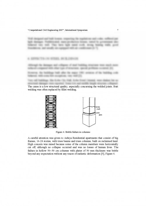
The morning of January 17, 1995 has changed dramatically the life in the very densely populated area of Japanese city of Kobe and vicinity.
The "Hanshin Dai Shinsai" occurred at 5:46 am and took the life of 6055 people and injured more than 30000 people. From the point of view of the number of victims, the Great Hanshin-Awaji Earthquake is the second in the Japanese (recorded) history, Table 1.
Table 1. Number of victims caused by major Japanese earthquakes
Earthquake's name
Date
Magnitude
Dead and Missing
1. Great Kanto
1923.09.01
7.9
142807
2. Great Hanshin
1995.01.17
7.2
6055
3. Fukui
1948.06.28
7.1
3848
4. Sanriku-Oki-Tsunami
1933.03.03
8.1
3008
5. Kita-Tango
1927.03.07
7.3
2925
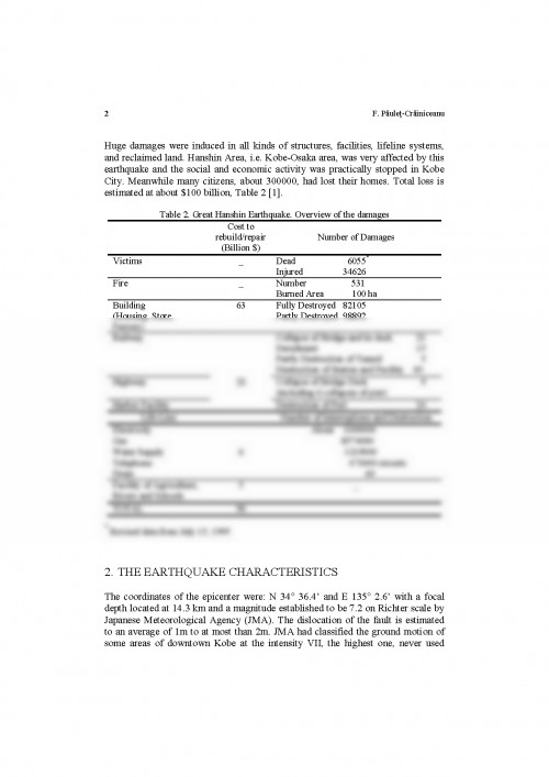
Huge damages were induced in all kinds of structures, facilities, lifeline systems, and reclaimed land. Hanshin Area, i.e. Kobe-Osaka area, was very affected by this earthquake and the social and economic activity was practically stopped in Kobe City. Meanwhile many citizens, about 300000, had lost their homes. Total loss is estimated at about $100 billion, Table 2 [1].
Table 2. Great Hanshin Earthquake. Overview of the damages
Cost to rebuild/repair
(Billion $)
Number of Damages
Victims
_
Dead 6055*
Injured 34626
Fire
_
Number 531
Burned Area 100 ha
Building
(Housing, Store, Factory)
63
Fully Destroyed 82105
Partly Destroyed 98892
Railway
Collapse of Bridge and its deck 21
Derailment 15
Partly Destruction of Tunnel 5
Destruction of Station and Facility 40
Highway
22
Collapse of Bridge Deck 9
(including 6 collapses of pier)
Harbor Facility
Destruction of Port 24
Life-Line
Number of Interruptions and Destruction
Electricity
About 1000000
Gas
8574000
Water Supply
6
1219000
Telephone
473000 circuits
Drain
60
Facility of Agriculture, Rivers and Schools
5
_
TOTAL
96
* Revised data from July 15, 1995
2. THE EARTHQUAKE CHARACTERISTICS
The coordinates of the epicenter were: N 34? 36.4' and E 135? 2.6' with a focal depth located at 14.3 km and a magnitude established to be 7.2 on Richter scale by Japanese Meteorological Agency (JMA). The dislocation of the fault is estimated to an average of 1m to at most than 2m. JMA had classified the ground motion of some areas of downtown Kobe at the intensity VII, the highest one, never used
"Computational Civil Engineering 2007", International Symposium 3
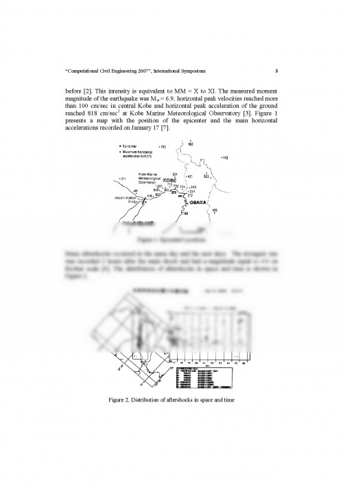
before [2]. This intensity is equivalent to MM = X to XI. The measured moment magnitude of the earthquake was Mw = 6.9, horizontal peak velocities reached more than 100 cm/sec in central Kobe and horizontal peak acceleration of the ground reached 818 cm/sec2 at Kobe Marine Meteorological Observatory [3]. Figure 1 presents a map with the position of the epicenter and the main horizontal accelerations recorded on January 17 [7].
Earthquake Engineering - tema de casa
Pentru a descărca acest document,
trebuie să te autentifici in contul tău.